For nearly five millennia, the ancient Egyptians cultivated a unique material culture profoundly influenced by their geography, natural resources, and the vital relationship with the Nile River. The Greek historian Herodotus, in the 5th century BCE, famously described Lower Egypt as a “gift of the river” (Herodotus, 2.5). While his observations primarily focused on the northern regions and the Delta, this sentiment resonates across the entire expanse of the Nile River Valley. The Nile was central to every facet of Egyptian life—providing sustenance, fertile land for agriculture, a means of transport, and facilitating the movement of materials for monumental building projects. Essentially, the Nile served as a lifeline, breathing life into the arid desert landscape.
The name "Nile" is derived from the Greek term Nelios, while the ancient Egyptians referred to it as Iteru, meaning "River." Spanning approximately 6,825 kilometers, the Nile is recognized as the longest river in the world. Its system consists of three principal branches: the White Nile, the Blue Nile, and the Atbara River. The White Nile, originating from Lake Victoria and Lake Albert, serves as the river's headwaters. The Blue Nile is crucial for the annual inundation, contributing the majority of the river’s water and nutrient-rich silt, while the Atbara River flows infrequently and has less impact on the overall system.
In the southern regions of Egypt, a series of six cataracts commence at Aswan. A cataract refers to shallow, turbulent waters where the river encounters resistant rock formations. These cataracts, primarily composed of granite outcroppings, create challenging navigation conditions for boats, establishing a natural boundary at Aswan and separating Egypt from its southern neighbor, Nubia.
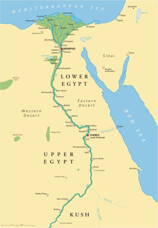
Geographically, ancient Egypt was located in Northeastern Africa and can be divided into four distinct zones: the Delta, the Western Desert, the Eastern Desert, and the Nile Valley. Each zone possesses its own unique environment and plays a distinct role within the Egyptian state. Urban centers could only thrive in the Nile Delta, Nile Valley, or the desert oases, where inhabitants had access to water, arable land, and essential resources. The ancient Egyptians, astute observers of nature, associated the Nile Valley with life and abundance while viewing the adjacent deserts as symbols of death and chaos.
The fertile land of the Nile Valley was referred to as Kemet, meaning "black land," in contrast to the arid desert known as Deshret, or "red land." This dichotomy was not merely geographical; it profoundly influenced daily life for the Egyptians. The desert's dry climate rendered it an ideal setting for cemeteries, preserving tombs and their contents while protecting them from the annual floods of the Nile. This preservation, combined with the sparsity of human habitation in the desert, explains why so much of what archaeologists study comes from funerary contexts.
The landscapes of Upper and Lower Egypt exhibited notable differences. The term Tawy signifies "Two Lands," referring to these two primary regions. Lower Egypt, located in the north, encompasses the Nile Delta, while Upper Egypt lies to the south. Although this nomenclature may seem counterintuitive relative to their geographical positions, it reflects the south-to-north flow of the Nile River.
The expansive floodplain of the Nile Delta, contrasted with the narrow band of fertile land found in the Nile Valley, led to diverse lifestyles. In the Delta, towns and cemeteries were constructed on natural highpoints, known as turtlebacks, which became islands during the inundation. Additionally, the Delta's proximity to the Mediterranean Sea made it a vital hub for trade and international relations, fostering a multicultural environment throughout Egyptian history.
The Egyptians perceived their king as the unifier of the “Two Lands.” A crucial responsibility of the king was to maintain the unity of Upper and Lower Egypt, visually represented through the sema-tawy motif, where two Nile deities are depicted uniting the lands, each symbolized by their characteristic plant—the papyrus for Lower Egypt and the lotus for Upper Egypt.
The Egyptian calendar was intricately linked to the annual cycle of the Nile, encompassing three primary seasons: Akhet (the inundation period), Peret (the growing season), and Shemu (the harvest season). Nilometers were constructed to measure and track the height of the annual floods, akin to how contemporary farmers might use almanacs. One particularly well-preserved Nilometer can be found on Elephantine Island at Aswan.
The Egyptians’ deep connection with the Nile led them to associate several deities with the river's cycles and the fertility it bestowed. Hapi, for instance, personified the life force of the Nile and represented its annual inundation, characterized by a round belly symbolizing abundance. Osiris, primarily recognized as the god of the afterlife, fundamentally embodies regeneration and rebirth; he is often depicted with black skin, symbolizing the fertility of the Nile and its life-giving silt.
Moreover, the Nile functioned as a crucial highway for transportation, facilitating mining expeditions, trade, architectural projects, and general travel. The Egyptians were skilled boat builders, with images of boats appearing among the earliest designs on Predynastic vessels dating back to around 3500-3300 BCE. The accessibility of the river significantly reduced the time and labor required to transport large objects, such as stones and architectural elements. Boats also played a vital role in funerary practices, being integral to both the burial rites and the afterlife.
While this overview touches on just a few essential elements, it is evident that the natural environment of Egypt and the Nile River profoundly influenced every aspect of life in ancient Egypt. The river's fertile floodplain, abundant water, and nutrient-rich silt laid the foundation for a flourishing civilization and served as a continuous source of inspiration for the people of northeastern Africa during this pivotal period in history.